The Waterfall
Chase
Your
Waterfall Resource
Navigation
Submit
a Waterfall
About
Links
Disclaimer
Home
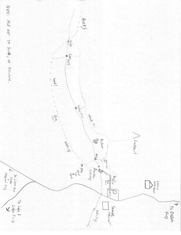
DeSoto State Park
Waterfall Circuit Hike
Getting to the park:
- Take I-59 to exit 218.
- Proceed towards Fort Payne (easterly direction) following signs to DeSoto State Park or Little River Canyon, AL-35 South.
- Turn left onto US-11 at the stop sign (soon to be a light).
- Proceed into downtown Fort Payne, which is the official sock capital of the world, and home to the band Alabama's fan club. Turn right onto south AL-35 after the city park.
- After railroad tracks and a long light, follow AL-35 up the mountain, making a sharp left after the tracks.
- After a mile or two encounter a light with a gas station and a restaurant, with signs for DeSoto State Park and Falls. Turn left onto DeKalb County Route 89.
- You will enter the park after around 5 miles.
DeSoto Falls:
- From the park sign, keep driving past the lodge road, past the country store, and follow the signs for , proceeding towards Mentone on CR 89.
- After a few miles you will encounter an intersection atop the mountain, with an electrical substation on the right. Turn right, following the signs, passing the substation, and entering the DeSoto Falls parking area. The falls is located at 34.54889N, -85.59056W, that's 34 32' 56”N -85 35' 26”W.
- From the parking area, head towards the dam, and you will see the short concrete path to the top overlook. More adventurous persons, or those with more time can hike to the bottom of the falls from another direction, but we have a busy schedule.
Azalea Cascades/Laurel Falls/Lost Falls
- From DeSoto Falls, go back the way you came and return to the main park area, proceeding just slightly past the little store/info center in the park, and locating the Azalea Cascades Boardwalk parking area on the right. Park.
- Follow the boardwalk until it ends. There's Azalea Cascades.
- Turn around, and locate the trail on the boardwalk side of the creek heading uphill. It should be blazed either red or orange.
- Hike up the hill, keeping a close watch for a trail on your right. It has either a red or orange blaze. Follow it through a big rock cut and uphill. Soon you will encounter the orange trail, and when you do, turn left. Proceed past the trail leading to the campgrounds, staying to the left when you meet it, remaining on the orange trial. Follow the orange trail around ¼ to ½ a mile, keeping a close eye out for a concrete “rock” on your left that says “Laurel Falls”. Follow the side trail to the falls.
- Return to the orange trail, resuming your previous direction, and hike another ¼ to ½ a mile looking for a similar “rock” that says “Lost Falls”, and follow that side trail.
- Return to your car.
** Take note, the blue trail is much more scenic, but much longer and more strenuous, and additionally, Laurel Falls is difficult to reach from it, ignoring that neither Laurel or Lost falls are labeled on the blue trail. Both the orange and blue trails lead to a lovely rocky area with lichen and moss upstream from Lost Falls. Also note that the area around both falls is slick and dangerous. Keep an eye on yourself and your children/pets. The orange trail is very rocky.
- Return to the parking area the way you came, grab a drink and maybe a snack. Remove the pebbles from your shoes, and get ready to hit the last two falls.
Indian Falls
- Okay, here's the hard one. Look across the street from the parking area. See that fenced building? It is a sewage treatment plant. Suppress your disgust and walk towards it, crossing the street carefully, being sure to look both ways and hold hands.
- You'll notice a sign pointing right towards “Indian Falls”, go right. There's another sign at the end of the fence pointing left towards “Indian Falls”, go left. See the bridge? Cross it. Enjoy the falls.
Lodge Falls
- Go back to your car.
- Get in. Start it. Exit the parking area to the right, heading away from the store. Keep an eye out for a road on the left with a sign for the lodge. Go to the lodge.
- Park in front of the lodge. Behind the lodge's hotel segment to the left of the lodge is “Lodge Falls”, which can be reached by walking down the concrete walkway of the hotel, then crossing the stream and following the signs. It is hidden somewhat, but if you ask in the lodge, they'll help you.
You did it! 6 Waterfalls in one day. Got more time?
- If you find yourself with more time, take CR-89 back to AL-35, and turn left instead of going home. When you come to a bridge, before the bridge you will find the road that runs along the rim of Little River Canyon, and after the bridge the parking area for Little River Falls.
This document can be downloaded for printing at: http://waterfalls.szulecki.com/al/desoto.pdf
For further help, consult the maps below. A better map can be aquired at the store/information center in the park. I highly recommend you stop in and get one on your way past. Photographs of all six waterfalls can be found at http://waterfalls.szulecki.com