Your Waterfall Resource
Select State
AL
MD
Submit a Waterfall
About
Links
Disclaimer
Home
Rating: 4/5 (Conditioned on actually seeing it)
Confirmation: Visual/Personal Photograph
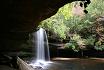
State: AL
County: Talladega County, near border with Clay and Cleburne Counties
General Location: Talladega National Forest - Near Hopeful, AL
Lat/Long: 33.50139 -85.90472
Map Link: Mapquest
Topographical Map Link: TerraServer
Description/Notes: Salt Creek Falls is probably the best cascade type waterfall in Alabama, and for that, it gets to be one of the most dangerous. Located in Talladega National Forest, it is a popular swimming area for local youths despite its deadly reputation. The cliffs on either side of the falls are very high. The falls themselves are at an angle that makes sliding down them enticing, but deadly. This falls is not for those who are afraid of high places, or who are very out of shape should it be a hot day. The trail is short, but leaving the falls is very uphill, almost as bad as the ascent out of the ampitheatre of Upper Caney Creek Falls, almost. Speaking of the ampitheatre, Salt Creek Falls has managed to create one heck of one. This is a very dangerous area, fast moving water and high rocks, be very careful.
Directions (From Talladega) via Google Maps
** Note, the place you want to park is by the power lines, NOT the closed Forest Service road a few hundred feet up the hill. That gated road is long and leads to a really unpleasantly steep series of trails. You are looking for a gravel parking area, unmarked, with a jeep stopping mound that has been pierced by a trail. Take that trail over the hill, and you'll be set.
Unless otherwise noted all images © Joshua Szulecki.